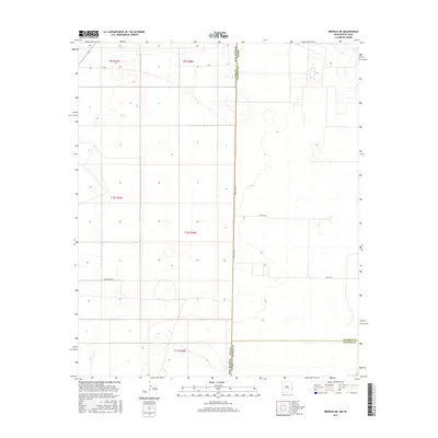
2017 Map of Bronco NE
USGS Topo · Published 2017About this map
The New Mexico-Texas state line dictates the layout of this High Plains landscape, where the survey grid meets the jurisdictional boundary between Lea County, New Mexico, and both Cochran and Yoakum counties in Texas. This 2017 edition shows a region defined by ranching infrastructure and local transit, with routes like V-Bar and Underwood Rd providing access to the interior sections. The eastern edge of the map, situated in the Texas Panhandle, is crossed by Co Rd 260, while State Line Rd runs directly along the border. The terrain is characterized by numerous small depressions and basins typical of the Llano Estacado, scattered across the townships of t9s r38e and t10s r38e. This map provides a clear view of the modern land divisions and rural road network that support the remote agricultural operations in this tri-county border area.
Find a feature on this map
13 named features on this map. Tap any name to fly to it.
Don’t see what you’re looking for? This feature index may not catch every label — zoom into the map to look around manually.
Map Details
Editions of this 2017 Bronco NE Map
This is the sole edition of this map. No revisions or reprints were ever made.
Other maps of this area

1954 · Brownfield
USGS Topo · 1:250,000

1958 · Brownfield
USGS Topo · 1:250,000

1962 · Brownfield
USGS Topo · 1:250,000

1970 · Bronco NE
USGS Topo · 1:24,000

1970 · Walking Cane Ranch
USGS Topo · 1:24,000

1970 · Gladiola
USGS Topo · 1:24,000

1970 · Bronco
USGS Topo · 1:24,000

1970 · Bledsoe
USGS Topo · 1:24,000

1970 · Morton SW
USGS Topo · 1:24,000
1971 · Two B Ranch NW
USGS Topo · 1:24,000