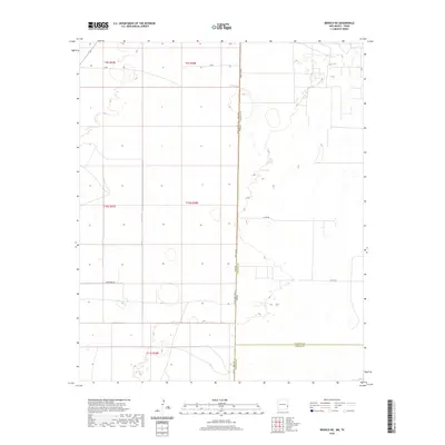
2020 Map of Bronco NE
USGS Topo · Published 2020About this map
V-Bar sits at the northern edge of this high plains landscape, where the administrative boundaries of New Mexico and Texas meet. This modern survey illustrates the expansive grid system of the Llano Estacado, defined by long stretches of gravel and paved roads like Underwood Rd and State Line Rd. The map documents a significant intersection of county and state lines, where Lea County, New Mexico, borders both Cochran and Yoakum Counties in Texas. The terrain is characterized by subtle depressions and the sparse infrastructure of ranching country, with Co Rd 260 and Fm 769 providing the primary transit routes across the state border. For researchers, this document provides the exact contemporary placement of property and township lines, including t9s r37e and t10s r38e, within this sparsely populated borderland.
Find a feature on this map
15 named features on this map. Tap any name to fly to it.
Don’t see what you’re looking for? This feature index may not catch every label — zoom into the map to look around manually.
Map Details
Editions of this 2020 Bronco NE Map
This is the sole edition of this map. No revisions or reprints were ever made.
Other maps of this area

1954 · Brownfield
USGS Topo · 1:250,000

1958 · Brownfield
USGS Topo · 1:250,000

1962 · Brownfield
USGS Topo · 1:250,000

1970 · Bronco NE
USGS Topo · 1:24,000

1970 · Walking Cane Ranch
USGS Topo · 1:24,000

1970 · Gladiola
USGS Topo · 1:24,000

1970 · Bronco
USGS Topo · 1:24,000

1970 · Bledsoe
USGS Topo · 1:24,000

1970 · Morton SW
USGS Topo · 1:24,000
1971 · Two B Ranch NW
USGS Topo · 1:24,000