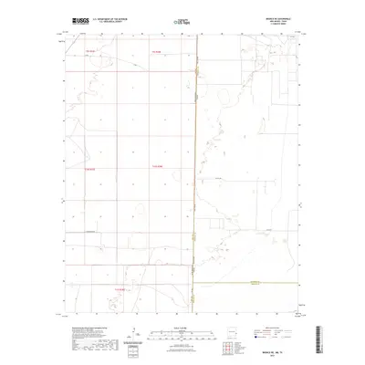
2023 Map of Bronco NE
USGS Topo · Published 2023About this map
State Line Rd traces the geometric border between New Mexico and Texas, a defining line in this high plains landscape of the Llano Estacado. The area is marked by a grid of rural infrastructure, including Underwood Rd and V-Bar, which navigate the wide-open ranching country. This 2023 survey by the U.S. Geological Survey shows a transition of counties as Lea and Cochran counties meet Yoakum County at the state boundary. Scattered depressions and seasonal basins punctuate the terrain, which is serviced by a sparse network of farm-to-market roads like Fm 769 and Fm 1585. The map provides a clear look at modern land division and road access in a region where the interstate boundary dictates the local geometry of travel and transport.
Find a feature on this map
15 named features on this map. Tap any name to fly to it.
Don’t see what you’re looking for? This feature index may not catch every label — zoom into the map to look around manually.
Map Details
Editions of this 2023 Bronco NE Map
This is the sole edition of this map. No revisions or reprints were ever made.
Other maps of this area

1954 · Brownfield
USGS Topo · 1:250,000

1958 · Brownfield
USGS Topo · 1:250,000

1962 · Brownfield
USGS Topo · 1:250,000

1970 · Bronco NE
USGS Topo · 1:24,000

1970 · Walking Cane Ranch
USGS Topo · 1:24,000

1970 · Gladiola
USGS Topo · 1:24,000

1970 · Bronco
USGS Topo · 1:24,000

1970 · Bledsoe
USGS Topo · 1:24,000

1970 · Morton SW
USGS Topo · 1:24,000
1971 · Two B Ranch NW
USGS Topo · 1:24,000