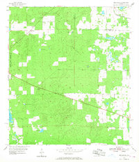
1955 Map of Bronson NE
USGS Topo · Published 1968About this map
Merediths and Adam anchor the northern landscape of this Levy County region during the mid-1950s, a period marked by the gradual transition of local industry. Phosphate or mineral extraction remains evident through the Sinclair Mine and Bailey Mine, both noted as inactive at the time of the survey. The transport of these materials and local timber is traced by the Seaboard Air Line and an old Railroad Grade that cuts through the dense wetlands.
Find a feature on this map
20 named features on this map. Tap any name to fly to it.
Don’t see what you’re looking for? This feature index may not catch every label — zoom into the map to look around manually.
Map Details
Editions of this 1955 Bronson NE Map
3 editions found
Other maps of this area

1890 · Arredondo
USGS Topo · 1:62,500

1892 · Arredondo
USGS Topo · 1:62,500

1894 · Arredondo
USGS Topo · 1:62,500

1895 · Williston
USGS Topo · 1:62,500

1954 · Bronson
USGS Topo · 1:24,000

1954 · Bronson SW
USGS Topo · 1:24,000

1954 · Gainesville
USGS Topo · 1:250,000

1955 · Bronson NE
USGS Topo · 1:24,000

1955 · Bronson SE
USGS Topo · 1:24,000
1957 · Bronson SE
USGS Topo · 1:25,000