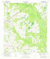
1973 Map of Bronwood
USGS Topo · Published 1975About this map
Bronwood and the rural agricultural lands of Terrell and Lee counties are captured in this early 1970s survey, defined by a network of Baptist and Methodist congregations and family cemeteries. The Central of Georgia railroad cuts diagonally through the landscape, anchoring the settlement of Bronwood and passing near prominent local features like Wolf Pit Pond. The terrain is drained by a complex system of waterways, including the winding Kinchahoonee Creek and its tributaries such as Middle Creek and Sugar Creek.
Find a feature on this map
28 named features on this map. Tap any name to fly to it.
Don’t see what you’re looking for? This feature index may not catch every label — zoom into the map to look around manually.
Map Details
Editions of this 1973 Bronwood Map
This is the sole edition of this map. No revisions or reprints were ever made.
Other maps of this area

1953 · Dothan
USGS Topo · 1:250,000

1954 · Dothan
USGS Topo · 1:250,000

1955 · Dothan
USGS Topo · 1:250,000

1956 · Sasser
USGS Topo · 1:62,500

1956 · Albany
USGS Topo · 1:62,500

1956 · Leslie
USGS Topo · 1:62,500

1973 · Chickasawhatchee
USGS Topo · 1:24,000

1973 · Sasser
USGS Topo · 1:24,000

1973 · Dawson
USGS Topo · 1:24,000
1973 · Bottsford
USGS Topo · 1:24,000