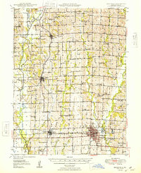
1948 Map of Brookfield
USGS Topo · Published 1948About this map
Brookfield and Linneus anchor this mid-century look at Linn County, where the Chicago Burlington and Quincy railroad cuts a straight line through the southern townships. The landscape is defined by the parallel courses of Locust Creek, Turkey Creek, and Yellow Creek, creating a series of north-south ridges that hosted numerous small community centers.
Find a feature on this map
74 named features on this map. Tap any name to fly to it.
Don’t see what you’re looking for? This feature index may not catch every label — zoom into the map to look around manually.
Map Details
Editions of this 1948 Brookfield Map
2 editions found
Other maps of this area

1924 · Chula
USGS Topo · 1:62,500

1924 · Hale
USGS Topo · 1:62,500

1946 · Brookfield
USGS Topo · 1:62,500

1946 · Galt
USGS Topo · 1:62,500

1947 · Chula
USGS Topo · 1:62,500

1948 · Brookfield
USGS Topo · 1:62,500

1949 · Sumner
USGS Topo · 1:24,000

1949 · Galt
USGS Topo · 1:62,500

1949 · Rothville
USGS Topo · 1:24,000

1949 · Bucklin
USGS Topo · 1:24,000