
1985 Map of Brookings
USGS Topo · Published 1991About this map
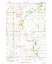
The Big Sioux River drainage system dominates this mid-1980s landscape across the border of South Dakota and Minnesota, where agricultural townships are defined by a dense network of wildlife management areas and regional water bodies. The city of Brookings serves as a primary hub, situated near the headwaters of Sixmile Creek and Medary Creek. To the east, the cultural and geological significance of Pipestone National Monument is clearly delineated near the city of Pipestone, alongside the Pipestone Indian State Wildlife Management Area. Transport and commerce in this era relied on the Chicago and North Western and Burlington Northern railroads, which linked grain-handling settlements like Elkton, Aurora, and Volga. Large glacial lakes such as Lake Benton, Lake Shaokatan, and Oakwood Lakes State Park provide significant recreational and ecological anchor points amidst the grid of sections.
Find a feature on this map
157 named features on this map. Tap any name to fly to it.
Don’t see what you’re looking for? This feature index may not catch every label — zoom into the map to look around manually.
Map Details
Editions of this 1985 Brookings Map
2 editions found

Other maps of this area

1953 · Watertown
USGS Topo · 1:250,000

1953 · New Ulm
USGS Topo · 1:250,000

1954 · Fairmont
USGS Topo · 1:250,000

1955 · Sioux Falls
USGS Topo · 1:250,000

1957 · New Ulm
USGS Topo · 1:250,000

1958 · New Ulm
USGS Topo · 1:250,000

1958 · Sioux Falls
USGS Topo · 1:250,000

1958 · Fairmont
USGS Topo · 1:250,000

1958 · Watertown
USGS Topo · 1:250,000
1963 · Trent
USGS Topo · 1:24,000