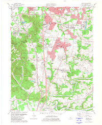
1981 Map of Brooks
USGS Topo · Published 1981About this map
Buttonmold Knob and the surrounding South Hills dominate this 1981 landscape where the expanding suburbs of southern Jefferson and Bullitt Counties meet the steep knobs of the Bluegrass region. Industrial activity is prominent along the Louisville and Nashville rail corridor, featuring the Hubers (Kenlite Station) facility and several active quarries and claypits. Residential growth is visible in the development of Hillview and Pioneer Village, while older rural anchors like Hebron Church and Little Flock Church remain central to the community. In the southern portion of the map, the terrain yields to the meandering course of Floyds Fork and the Salt River, where family-named landmarks like Stallings Cemetery and MacDonald Knob provide valuable points of reference for genealogists. The map also documents the modern infrastructure of the era, including the Interstate 65 corridor and the Holsclaw Lookout Tower.
Find a feature on this map
95 named features on this map. Tap any name to fly to it.
Don’t see what you’re looking for? This feature index may not catch every label — zoom into the map to look around manually.
Map Details
Editions of this 1981 Brooks Map
3 editions found
Other maps of this area

1907 · Louisville
USGS Topo · 1:62,500

1909 · Kosmosdale
USGS Topo · 1:48,000

1912 · Kosmosdale
USGS Topo · 1:62,500

1936 · Vine Grove
USGS Topo · 1:62,500

1943 · Vine Grove
USGS Topo · 1:62,500

1946 · Pitts Point
USGS Topo · 1:24,000

1946 · Vine Grove
USGS Topo · 1:62,500

1949 · Shepherdsville
USGS Topo · 1:24,000

1949 · Samuels
USGS Topo · 1:24,000

1949 · Shepherdsville
USGS Topo · 1:62,500