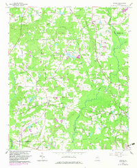
1965 Map of Brooks
USGS Topo · Published 1983About this map
The Central of Georgia Railroad anchors the rural landscape of southern Fayette County, linking the small communities of Woolsey and Brooks as it moves toward the Spalding County line. This mid-century view reveals a territory defined by its watercourses and early industrial sites, such as Morgan Mill on Whitewater Creek. The eastern boundary is dominated by the winding course of the Flint River, which separates the area from Clayton County. Smaller settlements like Vaughn, Rio, and Digbey are scattered throughout, often centered around family-named roads and country churches like Rising Star Ch and Antioch Ch. The 1980s updates, shown in purple, highlight localized growth near Kelley Lake and the Heads Cr Res, reflecting the subtle transition of this agricultural region over two decades of development.
Find a feature on this map
60 named features on this map. Tap any name to fly to it.
Don’t see what you’re looking for? This feature index may not catch every label — zoom into the map to look around manually.
Map Details
Editions of this 1965 Brooks Map
2 editions found
Other maps of this area

1953 · Atlanta
USGS Topo · 1:250,000

1957 · Atlanta
USGS Topo · 1:250,000

1958 · Atlanta
USGS Topo · 1:250,000

1965 · Tyrone
USGS Topo · 1:24,000
1965 · Hampton
USGS Topo · 1:24,000

1965 · Fayetteville
USGS Topo · 1:24,000

1965 · Senoia
USGS Topo · 1:24,000

1965 · Griffin North
USGS Topo · 1:24,000

1965 · Brooks
USGS Topo · 1:24,000

1971 · Hollonville
USGS Topo · 1:24,000