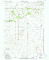
1962 Map of Brookston NW
USGS Topo · Published 1980About this map
Reynolds anchors the northeast corner of this agricultural landscape in White County, Indiana, as it appeared in the early 1960s with updates into the late 1970s. The region is defined by an extensive and sophisticated drainage network essential for the fertile plains of Princeton, West Point, and Prairie. Named waterways like Honey Creek, Big Creek, and Spring Creek are augmented by dozens of surveyed channels such as Hoagland Ditch and Scipio Ditch, reflecting the systematic effort to manage the local hydrology for farming. For those tracing family history, the map preserves the locations of West Point Cem and Lane Cem. Small clusters like White and Bndress dot the section lines, while a prominent Pipeline cuts diagonally across the southern townships of Round Grove and Prairie, illustrating the modern industrial infrastructure overlaying the traditional rural grid.
Find a feature on this map
26 named features on this map. Tap any name to fly to it.
Don’t see what you’re looking for? This feature index may not catch every label — zoom into the map to look around manually.
Map Details
Editions of this 1962 Brookston NW Map
3 editions found
Other maps of this area

1953 · Danville
USGS Topo · 1:250,000

1955 · Danville
USGS Topo · 1:250,000

1956 · Danville
USGS Topo · 1:250,000

1962 · Brookston SW
USGS Topo · 1:24,000

1962 · Monticello South
USGS Topo · 1:24,000
1962 · Round Grove
USGS Topo · 1:24,000

1962 · Templeton NE
USGS Topo · 1:24,000

1962 · Brookston NW
USGS Topo · 1:24,000

1962 · Monon
USGS Topo · 1:24,000

1962 · Monticello North
USGS Topo · 1:24,000