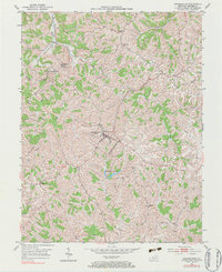
1952 Map of Brooksville
USGS Topo · Published 1983About this map
Brooksville serves as the central hub of this Bracken County landscape, situated amidst a dense network of ridges and narrow valleys. At the start of the 1950s, the area maintained a rural character defined by small crossroads settlements and family landmarks. Significant local history is captured in the placement of the County Home south of the main town and the Hamilton Cem near Chatham. The terrain is deeply incised by watercourses like Locust Creek, Willow Creek, and McCarty Creek, which shaped the early road patterns including KY 10 and KY 19. Smaller communities such as Powersville and Cumminsville appear as modest clusters of buildings, while spiritual life is anchored by country churches like Mt Zion Ch and Concord Ch. The Brooksville Reservoirs north of the primary settlement illustrate the early mid-century infrastructure supporting the growing county seat.
Find a feature on this map
26 named features on this map. Tap any name to fly to it.
Don’t see what you’re looking for? This feature index may not catch every label — zoom into the map to look around manually.
Map Details
Editions of this 1952 Brooksville Map
3 editions found

Other maps of this area

1915 · Maysville
USGS Topo · 1:62,500

1919 · Maysville
USGS Topo · 1:62,500

1928 · Higginsport
USGS Topo · 1:48,000

1931 · Felicity
USGS Topo · 1:62,500

1931 · Higginsport
USGS Topo · 1:62,500

1952 · Germantown
USGS Topo · 1:24,000

1952 · Higginsport
USGS Topo · 1:24,000

1952 · Sardis
USGS Topo · 1:24,000

1952 · Mount Olivet
USGS Topo · 1:24,000

1952 · Berlin
USGS Topo · 1:24,000