
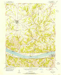
1952 Map of Higginsport
USGS Topo · Published 1953About this map
Augusta and Dover anchor this riverfront survey along the southern banks of the Ohio River in the early 1950s. The landscape is defined by the vital transportation corridor of the Chesapeake and Ohio railroad, which skirts the river's edge, connecting the riverside landings and stations like Higginsport Sta. Inland from the river, the terrain rises sharply toward prominent landmarks such as Stony Point, dissected by numerous watercourses including Bracken Creek, Raccoon Creek, and Lee Creek. This topographical detail reveals the historical settlement patterns of the region, where commerce and transit were tied to the water level—indicated here at a normal pool elevation of 441 feet—while local life took root in the valleys and on the heights, evidenced by sites like Rosemont Cem near the eastern edge of the map.
Find a feature on this map
18 named features on this map. Tap any name to fly to it.
Don’t see what you’re looking for? This feature index may not catch every label — zoom into the map to look around manually.
Map Details
Editions of this 1952 Higginsport Map
This is the sole edition of this map. No revisions or reprints were ever made.
Other maps of this area

1915 · Maysville
USGS Topo · 1:62,500

1919 · Maysville
USGS Topo · 1:62,500

1928 · Higginsport
USGS Topo · 1:48,000

1931 · Felicity
USGS Topo · 1:62,500

1931 · Higginsport
USGS Topo · 1:62,500

1952 · Germantown
USGS Topo · 1:24,000

1952 · Maysville West
USGS Topo · 1:24,000

1952 · Brooksville
USGS Topo · 1:24,000

1953 · Bethel
USGS Topo · 1:24,000
1953 · Felicity
USGS Topo · 1:24,000