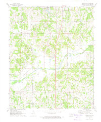
1972 Map of Brooksville
USGS Topo · Published 1974About this map
Brooksville and the surrounding Pottawatomie County landscape are defined by the winding course of the Little River and a scattering of rural institutions in the early 1970s. The area south of Tecumseh includes the Girls Town (State School) and several namesake land divisions such as Brinton and Burnett. This survey documents the transition of local infrastructure, where an Old Railroad Grade and Old Grade mark the paths of former rail lines through the valley.
Find a feature on this map
28 named features on this map. Tap any name to fly to it.
Don’t see what you’re looking for? This feature index may not catch every label — zoom into the map to look around manually.
Map Details
Editions of this 1972 Brooksville Map
2 editions found
Other maps of this area

1896 · Seminole and Prague
USGS Topo · 1:125,000

1898 · Purcell
USGS Topo · 1:125,000

1907 · Maud
USGS Topo · 1:62,500

1908 · Maud
USGS Topo · 1:62,500

1909 · Shawnee
USGS Topo · 1:62,500

1910 · McComb
USGS Topo · 1:62,500

1930 · McLoud
USGS Topo · 1:62,500

1954 · Oklahoma City
USGS Topo · 1:250,000

1957 · Oklahoma City
USGS Topo · 1:250,000
1958 · Tribbey
USGS Topo · 1:24,000