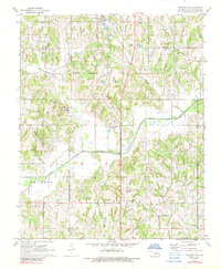
1972 Map of Brooksville
USGS Topo · Published 1989About this map
The Little River and Sand Creek basins define this central Oklahoma landscape south of Tecumseh, where early 1970s land use reflects a mix of agriculture and institutional presence. At the northern edge, the Girls Town (State School) occupies a significant area near the Corporate Boundary of the neighboring town. This survey provides exceptional detail for genealogists, recording numerous small burial grounds including Brooksville Cem, Ruggles Cem, and Prairie View Cem. An Old Railroad Grade cuts diagonally across the western sections, marking the path of former transit lines that once connected these rural townships. The settlement of Brooksville sits central to this network, while scattered Oil Wells and a Gaging Station indicate the ongoing industrial and environmental management of the Burnett and Moore regions during this era.
Find a feature on this map
25 named features on this map. Tap any name to fly to it.
Don’t see what you’re looking for? This feature index may not catch every label — zoom into the map to look around manually.
Map Details
Editions of this 1972 Brooksville Map
2 editions found
Other maps of this area

1896 · Seminole and Prague
USGS Topo · 1:125,000

1898 · Purcell
USGS Topo · 1:125,000

1907 · Maud
USGS Topo · 1:62,500

1908 · Maud
USGS Topo · 1:62,500

1909 · Shawnee
USGS Topo · 1:62,500

1910 · McComb
USGS Topo · 1:62,500

1930 · McLoud
USGS Topo · 1:62,500

1954 · Oklahoma City
USGS Topo · 1:250,000

1957 · Oklahoma City
USGS Topo · 1:250,000
1958 · Tribbey
USGS Topo · 1:24,000