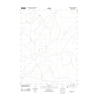
2012 Map of Browns Hill
USGS Topo · Published 2012About this map
Stratton Corral stands as a lonely outpost in this high-desert portion of Carbon County, where a sparse network of ranching roads and intermittent drainage channels define the landscape. The topography is dominated by local landmarks like Five Buttes and the namesake Browns Hill, providing significant vertical relief across an otherwise open range. The hydrologic system is characterized by seasonal forks and creeks, including the S Fork Cherokee Cr and the winding course of Loco Cr. Modern access to this remote interior is facilitated by primitive routes such as McCarty Canyon Rd, Wild Cow Rd, and Stock Dr, which suggest a continuing legacy of livestock management and land use into the twenty-first century.
Find a feature on this map
13 named features on this map. Tap any name to fly to it.
Don’t see what you’re looking for? This feature index may not catch every label — zoom into the map to look around manually.
Map Details
Editions of this 2012 Browns Hill Map
This is the sole edition of this map. No revisions or reprints were ever made.
Other maps of this area

1932 · Savery
USGS Topo · 1:96,000

1940 · Savery
USGS Topo · 1:125,000

1954 · Rawlins
USGS Topo · 1:250,000

1957 · Baggs
USGS Topo · 1:62,500

1957 · Doty Mountain
USGS Topo · 1:62,500

1958 · Rawlins
USGS Topo · 1:250,000
1961 · Savery
USGS Topo · 1:24,000
1961 · Browns Hill
USGS Topo · 1:24,000

1961 · Ketchum Buttes
USGS Topo · 1:24,000

1961 · Grieve Reservoir
USGS Topo · 1:24,000