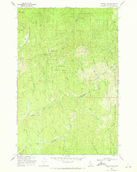
1969 Map of Browns Rock
USGS Topo · Published 1971About this map
Clearwater National Forest dominates this 1969 survey, revealing a landscape defined by industrial logging and high mountain peaks. The map details the remote reaches of the Idaho backcountry, where the legacies of forestry operations are visible in the names of Camp 10 Meadow and Camp 60. A prominent Railroad Grade snakes along the eastern edge near Tepee Creek, tracing the path of former timber transport through the steep terrain.
Find a feature on this map
34 named features on this map. Tap any name to fly to it.
Don’t see what you’re looking for? This feature index may not catch every label — zoom into the map to look around manually.
Map Details
Editions of this 1969 Browns Rock Map
3 editions found
Other maps of this area

1923 · Washington Creek
USGS Topo · 1:125,000

1936 · Boehls Butte
USGS Topo · 1:48,000

1938 · Headquarters
USGS Topo · 1:48,000

1943 · Boehls Butte
USGS Topo · 1:62,500

1944 · Headquarters
USGS Topo · 1:62,500

1956 · Hamilton
USGS Topo · 1:250,000

1959 · Hamilton
USGS Topo · 1:250,000

1960 · Hamilton
USGS Topo · 1:250,000

1963 · Sheep Mtn
USGS Topo · 1:24,000

1963 · Clarke Mtn
USGS Topo · 1:24,000