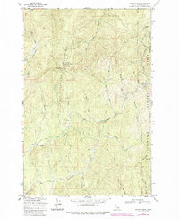
1969 Map of Browns Rock
USGS Topo · Published 1985About this map
Clearwater National Forest dominates this topographic study of the Clearwater County backcountry, revealing a landscape defined by timber operations and remote outposts during the late 1960s. The presence of Washington Cabin and Camp 60 suggests the seasonal habitation and work camps required for forest management and resource extraction in this steep drainage basin. An Old Railroad Grade winding through the western canyons provides a physical record of earlier logging infrastructure, showing how industrial access was carved into the drainages of Beaver Creek and South Fork Beaver Creek. To the east, the topography rises toward Deadhorse Mountain and Elk Mountain, where a Lookout Tower marks a high point for fire surveillance. The intricate network of Jeep Trails and features like the Gravel Pit near Browns Rock illustrate the mid-century transition from rail-based to road-based forest access.
Find a feature on this map
34 named features on this map. Tap any name to fly to it.
Don’t see what you’re looking for? This feature index may not catch every label — zoom into the map to look around manually.
Map Details
Editions of this 1969 Browns Rock Map
3 editions found
Other maps of this area

1923 · Washington Creek
USGS Topo · 1:125,000

1936 · Boehls Butte
USGS Topo · 1:48,000

1938 · Headquarters
USGS Topo · 1:48,000

1943 · Boehls Butte
USGS Topo · 1:62,500

1944 · Headquarters
USGS Topo · 1:62,500

1956 · Hamilton
USGS Topo · 1:250,000

1959 · Hamilton
USGS Topo · 1:250,000

1960 · Hamilton
USGS Topo · 1:250,000

1963 · Sheep Mtn
USGS Topo · 1:24,000

1963 · Clarke Mtn
USGS Topo · 1:24,000