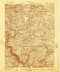
1904 Map of Bruceton
USGS Topo · Published 1921About this map
Big Sandy Creek and its many tributaries, including Little Sandy Creek, carve through the Preston County highlands in this early 20th-century survey. The landscape is defined by small, isolated rural centers such as Bruceton Mills and Clifton Mills, which highlight the importance of water power to the local economy of the era. The mapping details the Pennsylvania West Virginia Boundary Line at the northern edge, where the terrain rises toward Chestnut Ridge.
Find a feature on this map
57 named features on this map. Tap any name to fly to it.
Don’t see what you’re looking for? This feature index may not catch every label — zoom into the map to look around manually.
Map Details
Editions of this 1904 Bruceton Map
3 editions found

Other maps of this area

1886 · St. George
USGS Topo · 1:125,000

1891 · St. George
USGS Topo · 1:125,000

1895 · Piedmont
USGS Topo · 1:125,000

1899 · Oakland
USGS Topo · 1:62,500

1900 · Accident
USGS Topo · 1:62,500

1900 · Oakland
USGS Topo · 1:62,500

1900 · Uniontown
USGS Topo · 1:62,500

1900 · Masontown
USGS Topo · 1:62,500

1902 · Morgantown
USGS Topo · 1:62,500

1903 · Masontown
USGS Topo · 1:62,500