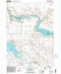
1992 Map of Bruneau
USGS Topo · Published 1992About this map
The confluence of the Snake River and the Bruneau River dominates this Idaho landscape, characterized by the expansive waters of the C J Strike Reservoir. The settlement of Bruneau serves as a focal point in the Bruneau Valley, situated near the Bruneau Guard Station and a local Rodeo Ground. This 1992 revision of earlier aerial photography shows a region balanced between wildlife conservation and historic passage. Significant land use is marked by the Snake River Birds of Prey Area and the C J Strike Wildlife Management Area, preserving the natural habitat along the canyon walls and riverbanks.
Find a feature on this map
29 named features on this map. Tap any name to fly to it.
Don’t see what you’re looking for? This feature index may not catch every label — zoom into the map to look around manually.
Map Details
Editions of this 1992 Bruneau Map
This is the sole edition of this map. No revisions or reprints were ever made.
Other maps of this area

1892 · Mountain Home
USGS Topo · 1:125,000

1893 · Mountain Home
USGS Topo · 1:125,000

1946 · Mouth of Bruneau
USGS Topo · 1:24,000

1947 · Little Valley
USGS Topo · 1:24,000

1947 · Bruneau
USGS Topo · 1:62,500

1947 · Sand Dunes
USGS Topo · 1:24,000

1947 · Bruneau
USGS Topo · 1:24,000

1947 · Sugar Valley
USGS Topo · 1:24,000

1947 · Hot Spring
USGS Topo · 1:24,000

1948 · Sand Dunes
USGS Topo · 1:24,000