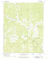
1968 Map of Brunot
USGS Topo · Published 1969About this map
Brunot and Beulah serve as the primary human touchpoints in this 1968 study of the Ozark foothills, where the landscape is defined by the winding course of Big Creek and its many tributaries. The area's social history is preserved through a high density of family and community burial grounds, including Lucy Cem, Chilton Cem, and Morris Cem, which are scattered among the ridges and creek valleys. These sites, along with the Full Gospel Ch, indicate a dispersed rural settlement pattern common to this part of Iron and Wayne counties during the mid-twentieth century.
Find a feature on this map
46 named features on this map. Tap any name to fly to it.
Don’t see what you’re looking for? This feature index may not catch every label — zoom into the map to look around manually.
Map Details
Editions of this 1968 Brunot Map
3 editions found
Other maps of this area

1926 · Des Arc
USGS Topo · 1:62,500

1929 · Des Arc
USGS Topo · 1:62,500

1930 · Coldwater
USGS Topo · 1:62,500

1932 · Piedmont
USGS Topo · 1:62,500

1934 · Greenville
USGS Topo · 1:62,500

1935 · Piedmont
USGS Topo · 1:62,500

1939 · Greenville
USGS Topo · 1:62,500

1949 · Rolla
USGS Topo · 1:250,000

1949 · Coldwater
USGS Topo · 1:62,500

1953 · Rolla
USGS Topo · 1:250,000