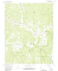
1968 Map of Brunot
USGS Topo · Published 1983About this map
Brunot and Beulah anchor this corner of the Missouri Ozarks during the late 1960s, a landscape defined by deeply incised hollows and family-named cemeteries. The map reveals a high concentration of burial sites reflecting the area's ancestral roots, including Meadows Cem, Lucy Cem, and Chilton Cem. The geography is characterized by prominent peaks like Stony Mountain, Hickman Mountain, and Rocky Mountain, while the southern portion transitions into the protected lands of Sam A Baker State Park and Graves Mountain State Forest. Water plays a central role in the local topography, from the Big Creek and Cedar Creek drainages to smaller features like the Shut-ins and Blue Spring. The presence of the Full Gospel Ch and numerous small springs, such as Weeping Willow Spring, points to a quiet, rural life sustained by the timber and water of Iron, Madison, and Wayne counties.
Find a feature on this map
49 named features on this map. Tap any name to fly to it.
Don’t see what you’re looking for? This feature index may not catch every label — zoom into the map to look around manually.
Map Details
Editions of this 1968 Brunot Map
3 editions found
Other maps of this area

1926 · Des Arc
USGS Topo · 1:62,500

1929 · Des Arc
USGS Topo · 1:62,500

1930 · Coldwater
USGS Topo · 1:62,500

1932 · Piedmont
USGS Topo · 1:62,500

1934 · Greenville
USGS Topo · 1:62,500

1935 · Piedmont
USGS Topo · 1:62,500

1939 · Greenville
USGS Topo · 1:62,500

1949 · Rolla
USGS Topo · 1:250,000

1949 · Coldwater
USGS Topo · 1:62,500

1953 · Rolla
USGS Topo · 1:250,000