
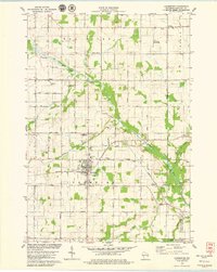
1978 Map of Brussels
USGS Topo · Published 1979About this map
The striking Niagara Escarpment defines the western terrain of this Door Peninsula landscape, running southeast past Brussels Hill. This 1970s survey captures the rural character of the border between Door and Kewaunee counties, where small settlements like Brussels and Kolberg serve as local hubs. The eastern portion of the sheet is dominated by the sprawling Black Ash Swamp and the waters of the Ahnapee River, which feeds into the Forestville Flowage. Genealogists and local historians will find significant detail in the placement of rural landmarks, including St Francis Ch and several family or parish burial grounds such as St Michaels Cem and Woller Cem. The map also traces the Ahnapee State Trail, following the former railroad corridor through the lowlands near Silver Creek.
Find a feature on this map
39 named features on this map. Tap any name to fly to it.
Don’t see what you’re looking for? This feature index may not catch every label — zoom into the map to look around manually.
Map Details
Editions of this 1978 Brussels Map
This is the sole edition of this map. No revisions or reprints were ever made.
Other maps of this area

1952 · Casco
USGS Topo · 1:62,500

1954 · Manitowoc
USGS Topo · 1:250,000

1958 · Manitowoc
USGS Topo · 1:250,000

1960 · Sturgeon Bay
USGS Topo · 1:62,500

1960 · Algoma
USGS Topo · 1:62,500

1961 · Little Sturgeon
USGS Topo · 1:62,500

1978 · Casco
USGS Topo · 1:24,000

1978 · Namur
USGS Topo · 1:24,000
1978 · Luxemburg
USGS Topo · 1:24,000

1981 · Sturgeon Bay West
USGS Topo · 1:24,000