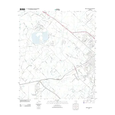
2013 Map of Bryan West
USGS Topo · Published 2013About this map
Benchley and the surrounding rural communities of Smetana and Fountain occupy this landscape north of the Texas A&M campus. The terrain is defined by the winding course of Thompsons Cr and its tributaries, including Thompsons Br and Still Cr, which feed into several small water bodies like Lake Mary and Dobrovolny Lake. The area reflects a mix of traditional agricultural land and growing suburban developments, connected by historic routes such as the Old Spanish Trl. Local heritage is preserved in numerous family and community burial grounds, including Canaan Cem, Goodson Cem, and Rest-Ever Memorial Cem. On the southwestern edge of the map, the Texas A and M Flight Test Station Airport stands as a notable landmark of technical and aviation history in Brazos County.
Find a feature on this map
172 named features on this map. Tap any name to fly to it.
Don’t see what you’re looking for? This feature index may not catch every label — zoom into the map to look around manually.
Map Details
Editions of this 2013 Bryan West Map
This is the sole edition of this map. No revisions or reprints were ever made.
Other maps of this area

1954 · Austin
USGS Topo · 1:250,000

1956 · Bryan
USGS Topo · 1:62,500

1956 · Caldwell
USGS Topo · 1:62,500

1961 · Mumford
USGS Topo · 1:24,000

1961 · Hearne South
USGS Topo · 1:24,000

1961 · Wellborn
USGS Topo · 1:24,000
1962 · Tunis
USGS Topo · 1:24,000
1962 · Chances Store
USGS Topo · 1:24,000

1962 · Bryan East
USGS Topo · 1:24,000
1962 · Bryan West
USGS Topo · 1:24,000