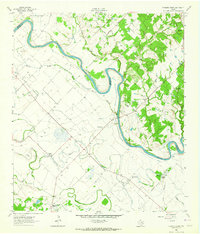
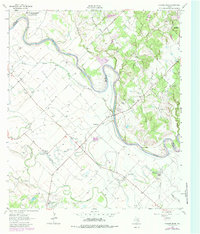
1962 Map of Chances Store
USGS Topo · Published 1964About this map
The Brazos River creates a meandering border between Brazos and Burleson counties, anchoring a rural landscape defined by extensive river bottomlands and scattered agrarian settlements in the early 1960s. Local commerce and community life center on small hubs like Chances Store and Fosters Store, while higher education and military operations expand from the east at College Station and the northwest corner near Bryan Air Force Base. The map reveals a dense network of country institutions, including the Newsome Cemetery, Jones High School, and several rural sanctuaries such as Clayton Church and St Mark Church. The terrain is shaped by an intricate system of waterways, including Middle Bayou, Butler Bayou, and the Old River channel, which illustrate the historical shifts of the Brazos through this fertile central Texas valley.
Find a feature on this map
26 named features on this map. Tap any name to fly to it.
Don’t see what you’re looking for? This feature index may not catch every label — zoom into the map to look around manually.
Map Details
Editions of this 1962 Chances Store Map
5 editions found
Other maps of this area

1914 · Gay Hill
USGS Topo · 1:62,500

1954 · Austin
USGS Topo · 1:250,000

1956 · Bryan
USGS Topo · 1:62,500

1956 · Caldwell
USGS Topo · 1:62,500

1956 · Somerville
USGS Topo · 1:62,500

1959 · Clay
USGS Topo · 1:24,000

1960 · Lyons
USGS Topo · 1:24,000
1960 · Snook
USGS Topo · 1:24,000

1961 · Mumford
USGS Topo · 1:24,000

1961 · Wellborn
USGS Topo · 1:24,000