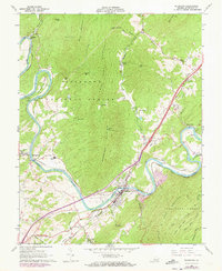
1961 Map of Buchanan
USGS Topo · Published 1973About this map
The James River carves a dramatic series of horseshoe bends through the heart of this Botetourt County landscape, including the sharp turn at Dillon. This 1961 survey, updated with 1972 aerial photography, documents the industrial and transport infrastructure of Buchanan, where the Chesapeake and Ohio and Norfolk and Western railroads converge along the riverbanks. The town is anchored by local landmarks like the Fairview Cemetery and the Assembly of God Ch.
Find a feature on this map
63 named features on this map. Tap any name to fly to it.
Don’t see what you’re looking for? This feature index may not catch every label — zoom into the map to look around manually.
Map Details
Editions of this 1961 Buchanan Map
3 editions found
Other maps of this area

1890 · Roanoke
USGS Topo · 1:125,000

1891 · Roanoke
USGS Topo · 1:125,000

1894 · Natural Bridge
USGS Topo · 1:125,000

1894 · Natural Bridge
USGS Topo · 1:62,500

1907 · Natural Bridge Special
USGS Topo · 1:62,500

1913 · Eagle Rock
USGS Topo · 1:48,000

1915 · Eagle Rock
USGS Topo · 1:62,500

1929 · Roanoke
USGS Topo · 1:48,000

1933 · Roanoke
USGS Topo · 1:62,500

1947 · Roanoke
USGS Topo · 1:250,000