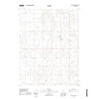
2020 Map of Buck Camp Canyon
USGS Topo · Published 2020About this map
Bitter Creek Corral sits as a solitary man-made landmark within the high desert plateaus of Uintah County. The landscape is defined by extensive upland formations like Archy Bench and East Bench, which overlook a network of seasonal drainage systems including Itentrouble Wash and the namesake Buck Camp Canyon. The terrain here is sharply broken, falling away from the heights of Hells Edge toward the valley of Bitter Creek. Transport and utility access in this remote corner of Utah are traced through long-established routes such as Bitter Creek Rd and the Texaco Survey line, reflecting the area's history of energy exploration and livestock management. This topographic study documents the drainage patterns and landforms that have dictated human movement through these canyons for generations.
Find a feature on this map
9 named features on this map. Tap any name to fly to it.
Don’t see what you’re looking for? This feature index may not catch every label — zoom into the map to look around manually.
Map Details
Editions of this 2020 Buck Camp Canyon Map
This is the sole edition of this map. No revisions or reprints were ever made.
Other maps of this area

1885 · East Tavaputs
USGS Topo · 1:250,000

1956 · Grand Junction
USGS Topo · 1:250,000

1959 · Grand Junction
USGS Topo · 1:250,000

1960 · Grand Junction
USGS Topo · 1:250,000

1962 · Grand Junction
USGS Topo · 1:250,000

1964 · Grand Junction
USGS Topo · 1:250,000

1965 · Grand Junction
USGS Topo · 1:250,000

1966 · Bates Knolls
USGS Topo · 1:24,000
1966 · Agency Draw NE
USGS Topo · 1:24,000
1966 · Copper Canyon
USGS Topo · 1:24,000