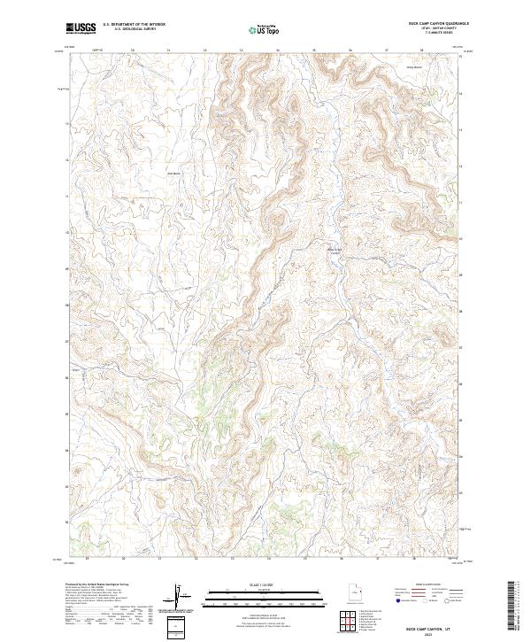
2023 Map of Buck Camp Canyon
USGS Topo · Published 2023About this map
Buck Camp Canyon and the high desert plateaus of Uintah County define this modern topographic landscape. The area is marked by significant topographical relief, where the steep drop-offs of Hells Edge overlook complex drainage systems such as Zentrouble Wash. Industrial and ranching access is evidenced by the presence of the Bitter Creek Rd and the Texaco Survey, which traverse the arid terrain to reach remote interior points. Settlement is sparse in this portion of the Uinta Basin, represented primarily by the Bitter Creek Corral located near the banks of Bitter Creek. Broad elevations like Archy Bench and East Bench provide a sense of the vast tableland structure that dominates this part of eastern Utah, showing how transport and land use are dictated by the natural corridors of the canyon systems.
Find a feature on this map
19 named features on this map. Tap any name to fly to it.
Don’t see what you’re looking for? This feature index may not catch every label — zoom into the map to look around manually.
Map Details
Editions of this 2023 Buck Camp Canyon Map
This is the sole edition of this map. No revisions or reprints were ever made.
Other maps of this area

1885 · East Tavaputs
USGS Topo · 1:250,000

1956 · Grand Junction
USGS Topo · 1:250,000

1959 · Grand Junction
USGS Topo · 1:250,000

1960 · Grand Junction
USGS Topo · 1:250,000

1962 · Grand Junction
USGS Topo · 1:250,000

1964 · Grand Junction
USGS Topo · 1:250,000

1965 · Grand Junction
USGS Topo · 1:250,000

1966 · Bates Knolls
USGS Topo · 1:24,000
1966 · Agency Draw NE
USGS Topo · 1:24,000
1966 · Copper Canyon
USGS Topo · 1:24,000