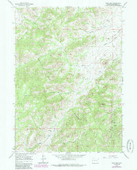
1964 Map of Buck Peak
USGS Topo · Published 1985About this map
Medicine Bow National Forest dominates this landscape, where the high ridges of the Laramie Range meet a network of headwater streams. In the mid-1960s, this area remained characterized by remote homesteads and ranching outposts, such as the Snowshoe Ranch and the Buck Place in the central hills. The drainage patterns are intricate, with Box Elder Creek and Gunnysack Creek carving through the terrain between prominent summits like Buck Peak and Lookout Peak. A localized sense of community is visible at the Box Elder Sch, which served the scattered families living along the creek draws. The map illustrates a rural economy tied to the land, marked by established grazing boundaries and seasonal water sources like Snowshoe Gulch and Keely Draw. This 1985 publication reflects data from 1964, documenting the ranching infrastructure before modern developments changed the character of the Wyoming backcountry.
Find a feature on this map
24 named features on this map. Tap any name to fly to it.
Don’t see what you’re looking for? This feature index may not catch every label — zoom into the map to look around manually.
Map Details
Editions of this 1964 Buck Peak Map
3 editions found
Other maps of this area

1954 · Torrington
USGS Topo · 1:250,000

1955 · Casper
USGS Topo · 1:250,000

1958 · Casper
USGS Topo · 1:250,000

1958 · Torrington
USGS Topo · 1:250,000

1959 · Squaw Spring
USGS Topo · 1:24,000

1960 · Banner Mtn
USGS Topo · 1:24,000

1960 · Reno Hill
USGS Topo · 1:24,000

1962 · Casper
USGS Topo · 1:250,000

1964 · Buck Peak
USGS Topo · 1:24,000

1964 · Buffalo Peak
USGS Topo · 1:24,000