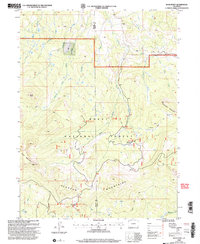
2000 Map of Buck Point
USGS Topo · Published 2004About this map
The Elkhead Mountains dominate this high-altitude landscape along the border of Moffat and Routt counties. Situated within the Routt National Forest, the region is characterized by a dense network of watercourses, including the Slater Creek and its various forks, which have carved significant drainages between peaks like Buck Point and Black Mountain. This survey reflects the late 20th-century management of these public lands, noting specialized forest service infrastructure such as the Lost Park Guard Sta and the Black Mountain Campground.
Find a feature on this map
30 named features on this map. Tap any name to fly to it.
Don’t see what you’re looking for? This feature index may not catch every label — zoom into the map to look around manually.
Map Details
Editions of this 2000 Buck Point Map
This is the sole edition of this map. No revisions or reprints were ever made.
Other maps of this area

1923 · Elkhead Creek
USGS Topo · 1:62,500

1923 · Pilot Knob
USGS Topo · 1:62,500

1924 · Elkhead Creek
USGS Topo · 1:62,500

1925 · Pilot Knob
USGS Topo · 1:62,500

1954 · Craig
USGS Topo · 1:250,000

1957 · Craig
USGS Topo · 1:250,000

1958 · Craig
USGS Topo · 1:250,000

1960 · Craig
USGS Topo · 1:250,000

1962 · Craig
USGS Topo · 1:250,000
1962 · Tumble Mountain
USGS Topo · 1:24,000