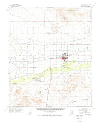
1958 Map of Buckeye
USGS Topo · Published 1963About this map
Agricultural development in the Gila River valley is the central theme of this mid-century survey, shown through an extensive network of irrigation works like the Lower Buckeye Canal and the Roosevelt Canal. The town of Buckeye serves as the regional hub, flanked by smaller settlements such as Allenville and Palo Verde. Beyond the irrigated fields, the landscape transitions into the specialized military and mining uses of the late 1950s, featuring the White Tanks Proving Grounds and several Luke Air Force Base auxiliary landing fields. The Southern Pacific railroad parallels the highway, connecting these desert communities to the broader Phoenix region. Local history is marked by landmarks like the Hazelton Memorial Cem and the ancient Petroglyphs found near the Buckeye Hills, while industrial activity is evidenced at the Blackhawk Mines and Good Earth Mine.
Find a feature on this map
56 named features on this map. Tap any name to fly to it.
Don’t see what you’re looking for? This feature index may not catch every label — zoom into the map to look around manually.
Map Details
Editions of this 1958 Buckeye Map
2 editions found

Other maps of this area

1946 · Avondale
USGS Topo · 1:62,500

1948 · Cashion
USGS Topo · 1:62,500

1951 · Mobile
USGS Topo · 1:62,500

1951 · Cotton Center
USGS Topo · 1:62,500

1951 · Woolsey Peak
USGS Topo · 1:62,500

1954 · Phoenix
USGS Topo · 1:250,000

1957 · Phoenix
USGS Topo · 1:250,000

1957 · White Tank Mts. SE
USGS Topo · 1:24,000

1957 · Valencia
USGS Topo · 1:24,000

1957 · Perryville
USGS Topo · 1:24,000