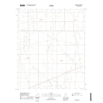
2020 Map of Buckeye NW
USGS Topo · Published 2020About this map
The High Plains of Lea County appear here as a landscape defined by an orderly grid of section lines and the specialized infrastructure of the oil and gas industry. Crossing the terrain at an angle to the Public Land Survey System, roads such as Patterson Rd and Martin Ranch Rd suggest the region's ranching heritage, while a network of service routes including Natural Rd and Wilbanks Rd provides access across the semi-arid environment. The topography is relatively level, marked by subtle depressions and the occasional complex of roads and pads that characterize this part of the Permian Basin. Local county routes like Co Rd 118 and Co Rd 121 link the remote sections of t16s r32e and t16s r33e, mapping out the essential connectivity of this high-desert territory.
Find a feature on this map
12 named features on this map. Tap any name to fly to it.
Don’t see what you’re looking for? This feature index may not catch every label — zoom into the map to look around manually.
Map Details
Editions of this 2020 Buckeye NW Map
This is the sole edition of this map. No revisions or reprints were ever made.
Other maps of this area

1954 · Hobbs
USGS Topo · 1:250,000

1954 · Brownfield
USGS Topo · 1:250,000

1958 · Brownfield
USGS Topo · 1:250,000

1958 · Hobbs
USGS Topo · 1:250,000

1962 · Brownfield
USGS Topo · 1:250,000

1962 · Buckeye
USGS Topo · 1:62,500

1963 · Maljamar
USGS Topo · 1:62,500

1973 · Fort Ranch
USGS Topo · 1:24,000

1973 · Dean Ranch
USGS Topo · 1:24,000
1973 · Cedar Point SE
USGS Topo · 1:24,000