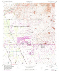
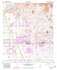
1956 Map of Buckhorn
USGS Topo · Published 1975About this map
Salt River Indian Reservation boundaries meet the northern edge of this desert landscape, where the Salt River flows past the base of the Usery Mts. The mid-1950s terrain is defined by a sophisticated network of irrigation infrastructure, including the Southern Canal, Roosevelt Canal, and Consolidated Canal, which support a transition from open desert to organized ranching and early suburban settlements. Falcon Field stands out as a prominent landmark with its swimming pool and proximity to the Apache Trail, a vital corridor for the region's mid-century growth.
Find a feature on this map
41 named features on this map. Tap any name to fly to it.
Don’t see what you’re looking for? This feature index may not catch every label — zoom into the map to look around manually.
Map Details
Editions of this 1956 Buckhorn Map
5 editions found
Other maps of this area

1904 · Camelback
USGS Topo · 1:62,500

1904 · Desert Well
USGS Topo · 1:62,500

1904 · Ft. McDowell
USGS Topo · 1:62,500

1906 · Camelsback
USGS Topo · 1:62,500

1906 · Ft. McDowell
USGS Topo · 1:62,500

1906 · Desert Well
USGS Topo · 1:62,500

1913 · Mesa
USGS Topo · 1:62,500

1915 · Mesa
USGS Topo · 1:62,500

1930 · Cave Creek
USGS Topo · 1:125,000

1939 · Cave Creek
USGS Topo · 1:125,000