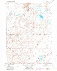
1951 Map of Bucklin Reservoirs
USGS Topo · Published 1982About this map
The California Emigrant Trail cuts through the high desert of Wyoming, tracing a path south of the winding Sweetwater River. This survey, compiled from 1950s data with later revisions, shows a landscape defined by ranching and essential water management. Family-named outposts like Cross L Ranch and Crane Ranch sit near the river's path, while the southern reaches are dominated by the Bucklin Reservoirs. The presence of numerous Windmills across the territory between Rawlins Draw and Muddy Creek highlights the critical role of groundwater for livestock in this arid region. Near the north-central border, the Y Z Ditch (Abandoned) serves as a silent record of earlier irrigation attempts along the riverbanks, contrasted by the active Soda Lake and Crane Reservoir.
Find a feature on this map
20 named features on this map. Tap any name to fly to it.
Don’t see what you’re looking for? This feature index may not catch every label — zoom into the map to look around manually.
Map Details
Editions of this 1951 Bucklin Reservoirs Map
3 editions found
Other maps of this area

1951 · Savage Peak
USGS Topo · 1:24,000

1951 · Bucklin Reservoirs
USGS Topo · 1:24,000

1951 · Lone Mountain
USGS Topo · 1:24,000

1951 · Split Rock
USGS Topo · 1:24,000

1951 · Lankin Dome
USGS Topo · 1:24,000

1955 · Casper
USGS Topo · 1:250,000

1958 · Casper
USGS Topo · 1:250,000

1959 · Miller Spring
USGS Topo · 1:24,000

1962 · Casper
USGS Topo · 1:250,000

1962 · Whiskey Peak
USGS Topo · 1:24,000