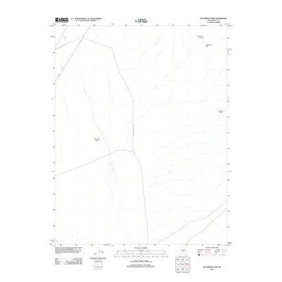
2012 Map of Buckwheat Rim
USGS Topo · Published 2012About this map
Hot Creek Valley occupies the center of this Great Basin landscape, where the ephemeral waters of Hot Creek flow through the arid high desert. This 2012 survey illustrates a sparse ranching and exploration infrastructure, dominated by the long north-south corridor of Twin Springs Ranch Rd. To the northwest, the intersection with Keystone Ruins Rd points toward the historical legacy of the region's mining and early settlement sites. The eastern edge of the quadrangle is defined by dramatic geological rises, including the steep Buckwheat Rim and the prominent Buckskin Point. These features, along with the deep incision of Monocline Canyon, highlight the structural complexity of Nye County's terrain as it was recorded at the start of the twenty-first century.
Find a feature on this map
7 named features on this map. Tap any name to fly to it.
Don’t see what you’re looking for? This feature index may not catch every label — zoom into the map to look around manually.
Map Details
Editions of this 2012 Buckwheat Rim Map
This is the sole edition of this map. No revisions or reprints were ever made.
Other maps of this area

1956 · Tonopah
USGS Topo · 1:250,000

1959 · Tonopah
USGS Topo · 1:250,000

1962 · Tonopah
USGS Topo · 1:250,000

1967 · Lunar Crater
USGS Topo · 1:62,500

1967 · Blue Jay Spring
USGS Topo · 1:24,000

1967 · Buckwheat Rim
USGS Topo · 1:24,000

1967 · Palisade Mesa
USGS Topo · 1:24,000

1967 · Lunar Crater
USGS Topo · 1:24,000
1967 · Chuck Wagon Flat
USGS Topo · 1:24,000

1967 · Tybo SE
USGS Topo · 1:24,000