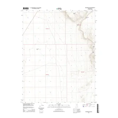
2014 Map of Buckwheat Rim
USGS Topo · Published 2014About this map
Hot Creek Valley dominates the western half of this Nevada landscape, where the intermittent drainage of Hot Cr threads through a broad alluvial basin. To the east, the topography shifts abruptly toward the high, structured elevations of the Pancake Range. This 2014 survey documents a classic Great Basin terrain defined by stark vertical relief, including the prominent shelf of Palisade Mesa and the sharp escarpment of Buckwheat Rim. The map provides a clear record of Public Land Survey System boundaries, showing township and range lines across the high desert. Researchers can trace the path of Monocline Canyon as it cuts through the upland formations near Buckskin Point, illustrating the geological complexity of this interior drainage system where water and landform meet in a remote section of Nye County.
Find a feature on this map
11 named features on this map. Tap any name to fly to it.
Don’t see what you’re looking for? This feature index may not catch every label — zoom into the map to look around manually.
Map Details
Editions of this 2014 Buckwheat Rim Map
This is the sole edition of this map. No revisions or reprints were ever made.
Other maps of this area

1956 · Tonopah
USGS Topo · 1:250,000

1959 · Tonopah
USGS Topo · 1:250,000

1962 · Tonopah
USGS Topo · 1:250,000

1967 · Lunar Crater
USGS Topo · 1:62,500

1967 · Blue Jay Spring
USGS Topo · 1:24,000

1967 · Buckwheat Rim
USGS Topo · 1:24,000

1967 · Palisade Mesa
USGS Topo · 1:24,000

1967 · Lunar Crater
USGS Topo · 1:24,000
1967 · Chuck Wagon Flat
USGS Topo · 1:24,000

1967 · Tybo SE
USGS Topo · 1:24,000