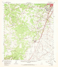
1958 Map of Buda
USGS Topo · Published 1968About this map
The Missouri Pacific railroad corridor anchors the eastern half of this Hill Country landscape, connecting the growing southern fringes of Austin with the established town of Buda. This late-1950s era transition is evident in the cluster of institutions and family landholdings, from the Science Hall and Joslin Sch to numerous ranch properties like Halifax Ranch and Rutherford Ranch. The terrain is defined by the headwaters and drainage of Onion Creek, Bear Creek, and Slaughter Creek, which cut through the limestone hills towards the Blanco River in the southwest. Cultural landmarks of the period are plentiful, including the Austin Speedway, the Friday Mountain (Boys Camp), and several rural congregations such as Center Union Ch and Santa Cruz Ch. Small settlements like Mountain City and Goforth remain distinct, reflecting a community structure before the suburban expansion of the capital region truly accelerated.
Find a feature on this map
86 named features on this map. Tap any name to fly to it.
Don’t see what you’re looking for? This feature index may not catch every label — zoom into the map to look around manually.
Map Details
Editions of this 1958 Buda Map
2 editions found
Other maps of this area

1887 · Blanco
USGS Topo · 1:125,000

1894 · Blanco
USGS Topo · 1:125,000

1896 · Austin
USGS Topo · 1:125,000

1897 · Austin
USGS Topo · 1:125,000

1910 · Austin
USGS Topo · 1:125,000

1911 · San Marcos
USGS Topo · 1:125,000

1919 · San Marcos
USGS Topo · 1:125,000

1929 · Hunter
USGS Topo · 1:62,500

1930 · Lockhart
USGS Topo · 1:62,500

1932 · Mt. Bonnell
USGS Topo · 1:62,500