
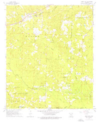
1962 Map of Buena Vista
USGS Topo · Published 1963About this map
St Louis Southwestern rails cut through the northwestern corner of this Ouachita County landscape, serving the settlement of Buena Vista. The area is defined by a transition from traditional rural landmarks to a mid-century petroleum economy. Dozens of derricks and pipelines are concentrated in the south, particularly within the Gum Creek Oil and Gas Field and the Pace City Oil and Gas Field near Pace City. These industrial zones contrast with the numerous country churches and family burial grounds that anchor the community's history, such as New Bethel Ch, Good Hope Cem, and Whitefield Cem. The terrain is deeply etched by a network of waterways including Ross Creek, Beech Creek, and Smackover Cr, which forms the southern boundary between Ouachita and Union counties.
Find a feature on this map
32 named features on this map. Tap any name to fly to it.
Don’t see what you’re looking for? This feature index may not catch every label — zoom into the map to look around manually.
Map Details
Editions of this 1962 Buena Vista Map
2 editions found
Other maps of this area

1901 · Gurdon
USGS Topo · 1:125,000

1903 · Camden
USGS Topo · 1:125,000

1951 · Camden
USGS Topo · 1:24,000

1953 · El Dorado
USGS Topo · 1:250,000

1957 · El Dorado
USGS Topo · 1:250,000

1958 · El Dorado
USGS Topo · 1:250,000

1960 · El Dorado
USGS Topo · 1:250,000

1962 · Lisbon
USGS Topo · 1:24,000

1962 · Louann
USGS Topo · 1:24,000

1962 · Mt Holly
USGS Topo · 1:24,000