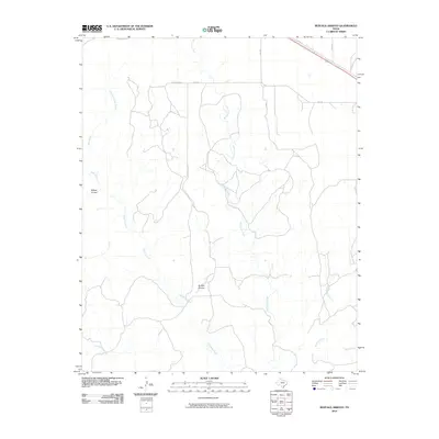
2010 Map of Buffalo Arroyo
USGS Topo · Published 2010About this map
Sheldon Ranch sits at the northern edge of this high plains landscape, a region defined by its complex network of drainage arroyos and creeks. In the early 21st century, the area remained predominantly open ranchland, with a road network including FM 2362 and Co RD N providing access across the terrain. The map meticulously documents the branching paths of McCullum Creek and Mulberry Creek, which carve their way through the central part of the quadrangle. Other notable watercourses such as Cottonwood Creek and Polecat Creek illustrate the natural drainage patterns of this portion of the Texas Panhandle. The presence of features like Willow Arroyo and the eponymous Buffalo Arroyo provides a look at the specific geographical landmarks that anchor local property boundaries and navigation in this rural stretch of Armstrong County.
Find a feature on this map
17 named features on this map. Tap any name to fly to it.
Don’t see what you’re looking for? This feature index may not catch every label — zoom into the map to look around manually.
Map Details
Editions of this 2010 Buffalo Arroyo Map
This is the sole edition of this map. No revisions or reprints were ever made.
Other maps of this area

1954 · Amarillo
USGS Topo · 1:250,000

1954 · Plainview
USGS Topo · 1:250,000

1958 · Amarillo
USGS Topo · 1:250,000

1958 · Plainview
USGS Topo · 1:250,000

1960 · Groom
USGS Topo · 1:62,500

1962 · Roach Ranch
USGS Topo · 1:24,000

1963 · Blue Hole Springs
USGS Topo · 1:24,000

1963 · Clarendon
USGS Topo · 1:24,000

1963 · Buffalo Arroyo
USGS Topo · 1:24,000

1963 · Paloduro
USGS Topo · 1:24,000