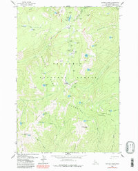
1979 Map of Buffalo Hump
USGS Topo · Published 1987About this map
Mining operations and historical campsites define this high-elevation region within the Gospel-Hump Wilderness and Nez Perce National Forest. The map documents a rugged legacy of extraction, centered around the prominent peak of Buffalo Hump. Numerous lode mines and sites like the Big Buffalo Mine, Jumbo Mine, and St Louis Mine are scattered across the slopes of Mineral Hill and Concord Hill. The presence of several former settlements, now labeled as sites, provides a record of early mountain outposts. Locations such as Humptown, Calendar, and Frogtown suggest a once-active community supported by the Atlas Mill and Jumbo Camp. This 1970s record, updated in the late 1980s, preserves the specific locations of the Mother Lode Mine and a remote Landing Strip amidst a landscape of high alpine lakes like Mirror Lake and Crescent Lake.
Find a feature on this map
71 named features on this map. Tap any name to fly to it.
Don’t see what you’re looking for? This feature index may not catch every label — zoom into the map to look around manually.
Map Details
Editions of this 1979 Buffalo Hump Map
3 editions found
Other maps of this area

1931 · Buffalo Hump
USGS Topo · 1:125,000

1934 · Buffalo Hump
USGS Topo · 1:125,000

1956 · Burgdorf
USGS Topo · 1:62,500

1956 · Warren
USGS Topo · 1:62,500

1956 · Elk City
USGS Topo · 1:250,000

1960 · Elk City
USGS Topo · 1:250,000

1963 · Sourdough Peak
USGS Topo · 1:24,000

1963 · Marble Butte
USGS Topo · 1:24,000

1977 · Silver Spur Ridge
USGS Topo · 1:24,000

1979 · Buffalo Hump
USGS Topo · 1:24,000