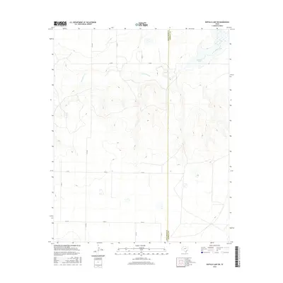
2016 Map of Buffalo Lake SW
USGS Topo · Published 2016About this map
Tierra Blanca Cr meanders across this High Plains landscape, cutting through the undulating topography of the Panhandle. The waterway feeds toward the northeast corner where it meets Buffalo Lake, a significant local hydrological feature. The map captures the intersection of Deaf Smith and Randall counties, defined by a long, straight north-south boundary line that bisects the terrain. This rural expanse is organized by a systematic grid of county roads, including Co Rd AA, Co Rd BB, and Co Rd 8, reflecting the agricultural land management typical of this region. The southern portion of the area is accessed via FM 1259, providing a primary paved link through the otherwise open, sectioned territory.
Find a feature on this map
12 named features on this map. Tap any name to fly to it.
Don’t see what you’re looking for? This feature index may not catch every label — zoom into the map to look around manually.
Map Details
Editions of this 2016 Buffalo Lake SW Map
This is the sole edition of this map. No revisions or reprints were ever made.
Other maps of this area

1954 · Clovis
USGS Topo · 1:250,000

1958 · Clovis
USGS Topo · 1:250,000

1961 · Buffalo Lake
USGS Topo · 1:62,500

1966 · Jumbo
USGS Topo · 1:24,000

1966 · Nazareth NW
USGS Topo · 1:24,000

1966 · Arney
USGS Topo · 1:24,000

1971 · Hereford NE
USGS Topo · 1:24,000

1971 · Hereford SE
USGS Topo · 1:24,000
1984 · Dawn
USGS Topo · 1:24,000
1984 · Umbarger
USGS Topo · 1:24,000