
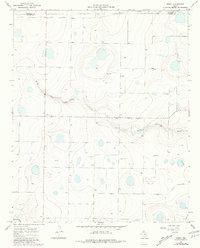
1966 Map of Arney
USGS Topo · Published 1968About this map
The community of Arney sits at the intersection of farm-to-market roads in the mid-1960s, serving as a quiet focal point in this Panhandle landscape. Located along the border where Randall Co meets Castro Co, the area is defined by its playa lakes and the winding paths of North Tule Draw and Middle Tule Draw. These drainage features carve subtle relief into the High Plains, illustrating the hydrological patterns of the Llano Estacado before modern large-scale irrigation changed the surface character. Numerous water wells dot the grid, indicating the reliance on the Ogallala Aquifer for the region's agricultural viability. The map captures the transition of the West Texas prairie into a structured network of section lines and rural ranching infrastructure, where the most prominent landmarks are the scattered natural depressions and the essential water sources that supported small settlements like Arney.
Find a feature on this map
5 named features on this map. Tap any name to fly to it.
Don’t see what you’re looking for? This feature index may not catch every label — zoom into the map to look around manually.
Map Details
Editions of this 1966 Arney Map
2 editions found
Other maps of this area

1954 · Plainview
USGS Topo · 1:250,000

1954 · Clovis
USGS Topo · 1:250,000

1958 · Clovis
USGS Topo · 1:250,000

1958 · Plainview
USGS Topo · 1:250,000

1960 · Canyon
USGS Topo · 1:62,500

1961 · Buffalo Lake
USGS Topo · 1:62,500

1965 · Lakeview
USGS Topo · 1:24,000

1965 · Nazareth SW
USGS Topo · 1:24,000

1965 · Nazareth
USGS Topo · 1:24,000

1966 · Tulia NW
USGS Topo · 1:24,000