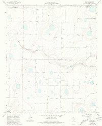
1966 Map of Arney
USGS Topo · Published 1981About this map
Arney serves as the primary point of settlement on this high plains landscape during the mid-1960s, situated just south of the Randall Co Castro Co boundary. The terrain is defined by a series of depressions and drainage patterns, most notably North Tule Draw and Middle Tule Draw, which cut through the agricultural surroundings. An extensive network of irrigation and water features is evident, with numerous locations marked simply as Well, reflecting the intensive groundwater reliance of the region. The proximity of County Line Road and a solitary Tower near the center of the sheet highlight the sparse but functional infrastructure of this rural Texas Panhandle area. Later revisions from 1979, noted in purple, illustrate subtle shifts in water management and land use before the map was finalized in the early 1980s.
Find a feature on this map
7 named features on this map. Tap any name to fly to it.
Don’t see what you’re looking for? This feature index may not catch every label — zoom into the map to look around manually.
Map Details
Editions of this 1966 Arney Map
2 editions found

Other maps of this area

1954 · Plainview
USGS Topo · 1:250,000

1954 · Clovis
USGS Topo · 1:250,000

1958 · Clovis
USGS Topo · 1:250,000

1958 · Plainview
USGS Topo · 1:250,000

1960 · Canyon
USGS Topo · 1:62,500

1961 · Buffalo Lake
USGS Topo · 1:62,500

1965 · Lakeview
USGS Topo · 1:24,000

1965 · Nazareth SW
USGS Topo · 1:24,000

1965 · Nazareth
USGS Topo · 1:24,000

1966 · Tulia NW
USGS Topo · 1:24,000