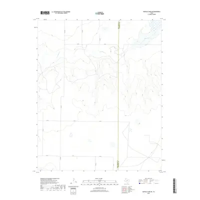
2019 Map of Buffalo Lake SW
USGS Topo · Published 2019About this map
Tierra Blanca Cr winds through the high plains of the Panhandle, defining the drainage patterns of this rural landscape on the border of Randall and Deaf Smith counties. The terrain is dominated by wide, open stretches and occasional depressional wetlands, or playas, typical of this region's geography. A strictly organized grid of county roads, including Co Rd 8 and Co Rd 5, provides the primary framework for navigation across the agricultural and ranching parcels. The presence of Fm 1259 in the southwestern portion of the sheet indicates a more established rural transportation corridor, connecting local ranch lands to the broader Texas farm-to-market system. This survey reflects the enduring spatial organization of the Panhandle, where watercourses like the Tierra Blanca Cr remain the most significant natural landmarks in an area primarily defined by large-scale land management.
Find a feature on this map
11 named features on this map. Tap any name to fly to it.
Don’t see what you’re looking for? This feature index may not catch every label — zoom into the map to look around manually.
Map Details
Editions of this 2019 Buffalo Lake SW Map
This is the sole edition of this map. No revisions or reprints were ever made.
Other maps of this area

1954 · Clovis
USGS Topo · 1:250,000

1958 · Clovis
USGS Topo · 1:250,000

1961 · Buffalo Lake
USGS Topo · 1:62,500

1966 · Jumbo
USGS Topo · 1:24,000

1966 · Nazareth NW
USGS Topo · 1:24,000

1966 · Arney
USGS Topo · 1:24,000

1971 · Hereford NE
USGS Topo · 1:24,000

1971 · Hereford SE
USGS Topo · 1:24,000
1984 · Dawn
USGS Topo · 1:24,000
1984 · Umbarger
USGS Topo · 1:24,000