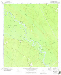
1978 Map of Bug Island
USGS Topo · Published 1978About this map
The Altamaha River Swamp dominates this landscape, where the shifting river channel creates a complex network of backwaters and named features like Old Hell Bight and Double Yellow Bluff. The geography is defined by the winding Altamaha and its many sloughs, including Steamboat River and the Sister Pine Drift. On the drier ground to the west, small settlements like Paradise Park and the Union Ch at Upper Sansavilla Landing mark the edge of the wetlands.
Find a feature on this map
67 named features on this map. Tap any name to fly to it.
Don’t see what you’re looking for? This feature index may not catch every label — zoom into the map to look around manually.
Map Details
Editions of this 1978 Bug Island Map
2 editions found
Other maps of this area

1918 · Jesup
USGS Topo · 1:62,500

1918 · Hortense
USGS Topo · 1:62,500

1918 · Everett City
USGS Topo · 1:62,500

1920 · Everett City
USGS Topo · 1:62,500

1943 · Ludowici
USGS Topo · 1:62,500

1943 · Jesup
USGS Topo · 1:62,500

1944 · Everett City
USGS Topo · 1:62,500

1944 · Hortense
USGS Topo · 1:62,500

1946 · Brunswick
USGS Topo · 1:250,000

1948 · Brunswick
USGS Topo · 1:250,000