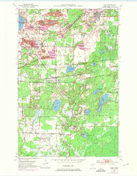
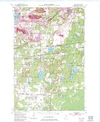
1951 Map of Buhl
USGS Topo · Published 1974About this map
Mining operations dominate the landscape of the Mesabi Iron Range, where the intensive extraction of ore has reshaped the earth around Buhl and Chisholm. Massive pits and expansive Mine Dumps surround the settlements, particularly evident at the Grant Mine and the Sherman Mine. This industrial footprint is contrasted by the proximity of established community life, including Buhl Park and the Lake View Cemetery. To the south, the terrain transitions into a more natural pattern of wetlands and lakes, such as Carey Lake and Sixmile Lake.
Find a feature on this map
42 named features on this map. Tap any name to fly to it.
Don’t see what you’re looking for? This feature index may not catch every label — zoom into the map to look around manually.
Map Details
Editions of this 1951 Buhl Map
6 editions found
Other maps of this area

1951 · Kinney
USGS Topo · 1:24,000

1951 · Kirk
USGS Topo · 1:24,000

1951 · Hibbing
USGS Topo · 1:24,000

1951 · Casco
USGS Topo · 1:24,000

1951 · Buhl
USGS Topo · 1:24,000

1952 · Riley
USGS Topo · 1:24,000

1952 · Little Swan
USGS Topo · 1:24,000

1954 · Hibbing
USGS Topo · 1:250,000

1955 · Dewey Lake SE
USGS Topo · 1:24,000

1955 · Dewey Lake
USGS Topo · 1:24,000