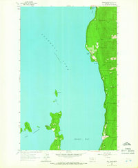
1964 Map of Bull Island
USGS Topo · Published 1966About this map
Flathead Lake dominates this mid-1960s survey, revealing a landscape defined by its glacial shoreline and scattered islands in Lake County. The map details the intricate geography of Finley Point and the adjacent passage known as The Narrows, which separates the mainland from Bull Island and Little Bull Island. Along the eastern shore, the presence of Yellow Bay State Park and several smaller inlets like Sunset Bay and Blue Bay indicates a shift toward recreational land use during this era. Interior drainage is marked by short, steep watercourses such as Teepee Creek and Talking Water Creek, which descend from the forested uplands toward the expansive waters of Skidoo Bay. Small structures and localized road networks clustered near the bays suggest the early development of seasonal residences and lakefront communities common to this portion of Montana.
Find a feature on this map
19 named features on this map. Tap any name to fly to it.
Don’t see what you’re looking for? This feature index may not catch every label — zoom into the map to look around manually.
Map Details
Editions of this 1964 Bull Island Map
4 editions found
Other maps of this area

1920 · Flathead Lake
USGS Topo · 1:125,000

1955 · Choteau
USGS Topo · 1:250,000

1956 · Wallace
USGS Topo · 1:250,000

1957 · Choteau
USGS Topo · 1:250,000

1958 · Choteau
USGS Topo · 1:250,000

1960 · Wallace
USGS Topo · 1:250,000

1962 · Choteau
USGS Topo · 1:250,000

1964 · Bull Island
USGS Topo · 1:24,000

1964 · Wild Horse Island
USGS Topo · 1:24,000

1964 · East Bay
USGS Topo · 1:24,000