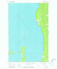
1964 Map of Bull Island
USGS Topo · Published 1981About this map
Finley Point and the eastern shores of Flathead Lake define this mid-century landscape of Lake County. The map details a period when the lake's eastern coastline was characterized by quiet bays and small islands, anchored by the protrusion of Finley Point and the navigational passage known as The Narrows. Along the shoreline, local landmarks like Yellow Bay State Park and Blue Bay suggest a region transitioning into a recreational hub, while the presence of a lone Station inland hints at the infrastructure supporting these lakeside communities.
Find a feature on this map
17 named features on this map. Tap any name to fly to it.
Don’t see what you’re looking for? This feature index may not catch every label — zoom into the map to look around manually.
Map Details
Editions of this 1964 Bull Island Map
4 editions found
Other maps of this area

1920 · Flathead Lake
USGS Topo · 1:125,000

1955 · Choteau
USGS Topo · 1:250,000

1956 · Wallace
USGS Topo · 1:250,000

1957 · Choteau
USGS Topo · 1:250,000

1958 · Choteau
USGS Topo · 1:250,000

1960 · Wallace
USGS Topo · 1:250,000

1962 · Choteau
USGS Topo · 1:250,000

1964 · Bull Island
USGS Topo · 1:24,000

1964 · Wild Horse Island
USGS Topo · 1:24,000

1964 · East Bay
USGS Topo · 1:24,000