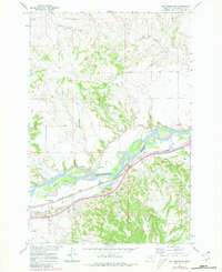
1967 Map of Bull Mountain
USGS Topo · Published 1980About this map
The Yellowstone River cuts through this high-plains landscape, defining the local geography with its complex system of irrigation and transport. Developed as part of the Missouri River Basin program, the map documents an era of managed water resources, featuring a series of large-scale diversions including the Main Canal, Waco Canal, and Waco Custer Canal. These engineered waterways contrast with the natural drainages of Hibbard Creek and Mill Creek that carve the northern uplands.
Find a feature on this map
18 named features on this map. Tap any name to fly to it.
Don’t see what you’re looking for? This feature index may not catch every label — zoom into the map to look around manually.
Map Details
Editions of this 1967 Bull Mountain Map
3 editions found
Other maps of this area

1894 · Fort Custer
USGS Topo · 1:125,000

1954 · Hardin
USGS Topo · 1:250,000

1954 · Forsyth
USGS Topo · 1:250,000

1957 · Hardin
USGS Topo · 1:250,000

1957 · Forsyth
USGS Topo · 1:250,000

1958 · Forsyth
USGS Topo · 1:250,000

1958 · Hardin
USGS Topo · 1:250,000

1960 · Coal Bank Creek
USGS Topo · 1:24,000
1960 · Lemon Ranch
USGS Topo · 1:24,000

1960 · Waco
USGS Topo · 1:24,000