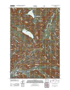
2011 Map of Bull Run Lake
USGS Topo · Published 2011About this map
Bull Run Lake and Lost Lake anchor this 2011 survey of the high-elevation drainages of the Bull Run River and the Sandy River. The landscape is defined by its complex hydrology and dramatic relief, with named features such as Dodge Island sitting within the blue expanse of the lake and Ramona Falls marking the descent of the Sandy River. A dense network of forest access is visible along the Lolo Pass Rd and Muddy Fork Rd, supporting recreational sites like the Ladd Creek Campground and Riley Horse Camp.
Find a feature on this map
47 named features on this map. Tap any name to fly to it.
Don’t see what you’re looking for? This feature index may not catch every label — zoom into the map to look around manually.
Map Details
Editions of this 2011 Bull Run Lake Map
This is the sole edition of this map. No revisions or reprints were ever made.
Other maps of this area

1924 · Mount Hood
USGS Topo · 1:125,000

1926 · Hood River
USGS Topo · 1:125,000

1927 · Mount Hood
USGS Topo · 1:125,000

1929 · Hood River
USGS Topo · 1:125,000

1953 · The Dalles
USGS Topo · 1:250,000

1956 · The Dalles
USGS Topo · 1:250,000

1957 · The Dalles
USGS Topo · 1:250,000

1957 · Bonneville Dam
USGS Topo · 1:62,500

1957 · Hood River
USGS Topo · 1:62,500
1962 · Hickman Butte
USGS Topo · 1:24,000