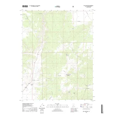
2020 Map of Bull Rush Peak
USGS Topo · Published 2020About this map
The Sevier River carves a path through this Garfield County landscape, marking the transition between open basins and high forest terrain. Near the settlement of Spry, the river enters the dramatic Circleville Canyon, while to the east, the boundaries of the Dixie National Forest encompass high-elevation landmarks such as Horse Valley Peak and Bull Rush Peak. This 2020 survey illustrates a modern backcountry infrastructure where historical water management at Marks Pond and Bucket Hollow Reservoir meets a contemporary network of recreational routes, including the Fremont Atv Trail and Snowbank Trail. The map provides a detailed view of the drainage patterns from Bull Rush Cr and Lost Cr, reflecting the vital role of water sources like Bull Rush Spring and Indian Spring in this high-desert environment.
Find a feature on this map
30 named features on this map. Tap any name to fly to it.
Don’t see what you’re looking for? This feature index may not catch every label — zoom into the map to look around manually.
Map Details
Editions of this 2020 Bull Rush Peak Map
This is the sole edition of this map. No revisions or reprints were ever made.
Other maps of this area

1885 · Beaver
USGS Topo · 1:250,000

1886 · Kanab
USGS Topo · 1:250,000

1953 · Richfield
USGS Topo · 1:250,000

1953 · Cedar City
USGS Topo · 1:250,000

1958 · Richfield
USGS Topo · 1:250,000

1958 · Cedar City
USGS Topo · 1:250,000

1962 · Cedar City
USGS Topo · 1:250,000

1966 · Bull Rush Peak
USGS Topo · 1:24,000

1966 · Circleville
USGS Topo · 1:24,000

1966 · Fremont Pass
USGS Topo · 1:24,000